This is Dave Zinn with the avalanche forecast for Tuesday, December 31st, at 7:00 a.m. This forecast is made possible by Yellowstone Ski Tours, Werner Wealth Management and the Bozeman Splitfest. This forecast does not apply to operating ski areas.
AVALANCHE WARNING
We are issuing an avalanche warning for the Bridger Mountain Range. The avalanche danger is HIGH on all slopes. Natural and human-triggered slides are likely. Heavy snowfall overloaded pre-existing weaknesses in the snowpack and created very dangerous avalanche conditions. Traveling in backcountry avalanche terrain is not recommended. Avoid traveling on or under slopes steeper than 30 degrees. Avalanches may be triggered from flat terrain underneath steeper slopes.
Website: www.mtavalanche.com
Avalanche Hotline: 406-587-6981
This warning will expire or be updated by 5:00 a.m. on Wednesday, January 1st.
This morning, temperatures are in the single digits and teens F with 5-10 mph winds from the west and the southwest. Winds are 15 mph, gusting to 30 from the west in the Bridger Range.
24 Hour Snow:
- Bridger Range: 20” of new snow with 1.6” of snow water equivalent (SWE)
- Northern Gallatin and Northern Madison Ranges: 4-8” of snow
- Centennial Range: 1” of snow
Today, temperatures will be in the teens and 20s F with 5-10 mph wind from the west and southwest. Light snowfall will result in a trace to an inch of new snow across the advisory area by tomorrow morning.
Avalanche Warning
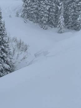
Very dangerous avalanche conditions exist in the Bridger Range north of Bozeman. In the last 36 hours, 27” of snow, equal to 2.8” of SWE, rapidly loaded the snowpack. And it is still snowing. Persistent slab avalanches will break deep in the snowpack and propagate across wide areas, and avalanches within the new and wind-drifted snow will be large enough to injure or kill a skier or rider. Yesterday, during the peak storm, a skier on the south side of Bradley’s Meadow was caught by an avalanche; thankfully, they were unharmed (details).
Natural and human-triggered slides are likely. Traveling in backcountry avalanche terrain is not recommended. Backcountry travelers may trigger avalanches from flat terrain below steeper slopes.
The avalanche danger is HIGH on all slopes.
A week of snowfall ended yesterday with snow totals measuring in the feet. Significant loading from new and wind-drifted snow results in dangerous avalanche conditions across the forecast area south of Bozeman through Island Park and Cooke City.
Storm Totals from the Last Week:
- Bridger Range: 34” of snow (3.5” SWE)
- Cooke City, Island Park and S. Madison Range: 22-25” of snow (2.5-2.9” SWE)
- Lionhead, Northern Madison and Northern Gallatin Range: 19-24” of snow (1.8-2.3” SWE)
Persistent slab avalanches can break across widely across slopes, failing on buried weak layers 1-3 feet deep (deeper on wind-loaded slopes), and avalanches breaking within new and wind-drifted snow, more sensitive to human triggers, will be large enough to bury or injure a rider or skier.
Recent Avalanche Activity:
- Yesterday, a skier in Cooke City reported several large collapses and a natural avalanche that broke 500 feet wide and 4-6 feet deep high on Henderson Mountain (photos and details)
- My partner and I had only skinned twenty minutes in Beehive Basin before triggering an avalanche on a test slope that propagated 150 feet wide, breaking one foot deep (media and details)
- Last weekend, we received vague reports of an avalanche that partially buried a rider in the Lionhead area (details), a snowmobiler triggered slides in Cabin Creek on test slopes (photos), and Ian and Alex saw a couple of small slides on Lionhead Ridge (obs and photo).
Employ cautious route-finding that minimizes exposure to slopes steeper than 30 degrees and avalanche runout zones. Avoid steep wind-loaded terrain in upper mountain bowls and at high elevations.
The avalanche danger is CONSIDERABLE. Today, if snowfall exceeds forecast amounts, expect increasing danger.
Enjoy the new snow, send in your snowpack observations and have a safe week.
Upcoming Avalanche Education and Events
Our education calendar is full of awareness lectures and field courses. Check it out: Events and Education Calendar
Wednesday, January 8, 2025, 7-9:30 p.m., Avy Savvy Night at the Colonial Theater, Idaho Falls. More information HERE.
We offer Avalanche Fundamentals with Field Session courses targeted towards non-motorized travelers in January and one geared towards motorized users. Sign up early before they fill up.
Every weekend in Cooke City: Friday at The Antlers at 7 p.m., Free Avalanche Awareness and Current Conditions talk, and Saturday from 10 a.m.-2 p.m. at Round Lake Warming Hut, Free Rescue Practice.
Friends of the Avalanche Center: Fall Fundraiser!
We’re still counting on your support and the online Fall Powder Blast fundraiser is 80% of the way to our goal. Please consider making even a small donation HERE or via Venmo
The observation platform went down for a short period yesterday evening. We apologize for the inconvenience. Thank you to everyone who tried to submit observations. Alternative routes include emailing mtavalanche@gmail.com, tagging us on social media, and calling the office phone at 406-587-6984


