This is Alex Marienthal with pre-season avalanche, weather and event information from the Gallatin National Forest Avalanche Center on Tuesday, November 8th. This information is sponsored by The Friends of the Avalanche Center and Spark R&D. Join them in supporting free and low-cost avalanche education, community outreach and avalanche center operations during the 2022 Virtual Powder Blast.
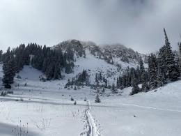
Since yesterday morning the mountains received 7-10” of new snow with the highest amounts near Big Sky, West Yellowstone and Cooke City. Yesterday, wind was south to southwest at 15-25 mph with gusts of 40-60 mph, and today wind has lessened to 10-15 mph with gusts of 20-35 mph. Temperatures will reach high 20s to low 30s today, except near Bozeman where they will remain in the teens to low 20s F. Over the next couple days, temperatures will gradually cool to single digits and near zero F by Thursday, and winds will be light to moderate and generally out of the south to east. More snow is expected tonight with 3-7” by morning and another 2-4” during the day tomorrow.
Avalanches continue to be likely with last night’s new snow and more snow expected tonight through tomorrow. Since Friday the mountains near Cooke City and West Yellowstone received over 2 feet of snow equal to 2.5-3” snow water equivalent (SWE) and near Bozeman and Big Sky received 1-1.5 feet of snow equal to 1-1.5” SWE.
Skiers, hunters, ice-climbers and snowmobilers should be extra cautious of travel on and across steep slopes, especially where wind has drifted the recent snow into thick slabs. Either avoid steep slopes all together, or carefully evaluate the snowpack and consequences of being caught in an avalanche. Avalanches can be large enough to bury a person, and will be especially dangerous if they pile deep in a narrow gully, or push you through rocks or trees.
Travel in the backcountry like you would any day of the winter. Carry an avalanche beacon, shovel and probe, and go with a partner. Take extra time to ensure your rescue gear is functional, not damaged, and you and your partners know how to use it.
Your observations are more important than ever this time of year as we get to know this season’s snowpack.
If you get out, please share avalanche, snowpack or weather observations via our website, email (mtavalanche@gmail.com), phone (406-587-6984), or Instagram (#gnfacobs).
Since Friday the mountains near Island Park received 2 feet of snow equal to 2.5” snow water equivalent. Avalanches continue to be likely with last night’s new snow and more snow expected tonight through tomorrow. Skiers, hunters, ice-climbers and snowmobilers should be extra cautious of travel on and across steep slopes, especially where wind has drifted the recent snow into thick slabs. Either avoid steep slopes all together, or carefully evaluate the snowpack and consequences of being caught in an avalanche. Carry an avalanche beacon, shovel and probe, and go with a partner. Take extra time to ensure your rescue gear is functional, not damaged, and you and your partners know how to use it.
Upcoming Avalanche Education and Events
Our education calendar is full of awareness lectures and field courses. Check it out: Events and Education Calendar.
Tomorrow, November 9, Earn Your Turns - A Night of Backcountry Inspired Snowboard Flicks at The Rialto. Tickets and Info Here.
The Utah Avalanche Center Snow and Avalanche Workshop is a great opportunity available online from 6-9 PM on November 9.
We are offering an Avalanche Fundamentals with Field Session course for skiers in December and January, and snowmobilers in early January. Sign up early before they fill up.
Friends of GNFAC Powder Blast Fundraiser
The Friends of the Avalanche Center are hosting the Virtual Powder Blast fundraiser. Your donations support free and low-cost avalanche education, beacon checkers at trailheads, beacon parks, weather stations, and GNFAC programs! The Friends of GNFAC launched an online GoFundMe campaign. Please consider a donation, and we look forward to having an in-person event again in the future.


